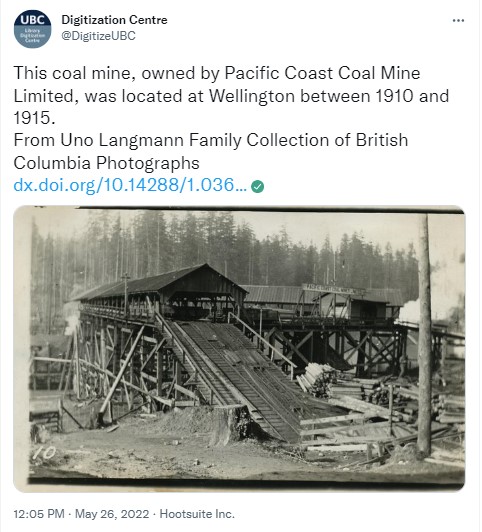
At the end of May 2022, the UBC Library Digitization Centre’s Twitter account featured a series of photos from their collection which depicted Nanaimo. I followed along closely because I love seeing old photos of Vancouver Island and of Nanaimo in particular. There was one photo from the Uno Langmann Family Collection of B.C. Photographs that immediately caught my interest because it was of above-ground coal mine structures.
The accompanying tweet read: “This coal mine, owned by Pacific Coast Coal Mine Limited, was located at Wellington between 1910 and 1915.” That made me pause, because having done some research on local coal mines, as well as being from the area, I know that Pacific Coast Coal Mines Ltd. was active in South Wellington, and not in Wellington, which was a Dunsmuir family interest.
I did some searching through the books I had at home and found a picture in South Wellington: Stories from the Past (a book complied by the South Wellington Historical Committee) of what I believe to be the same mine site from a different angle. This is a photo contributed by Jack Ruckledge and the mine is identified as the South Wellington Mine. That white “Pacific Coast Coal Mines Limited” sign on the roof of the building sure looks the same to me, but others can draw their own conclusions.

Above: South Wellington Mine photo found in South Wellington: Stories from the Past1
Photo used with permission of Helen Tilley

[Pacific Coast Coal Mine at Wellington, now Northern Nanaimo]
Photo UL_1088_0007 is from the Uno Langmann Family Collection of B.C. Photographs and is licensed under a
Creative Commons Attribution-NonCommercial-NoDerivatives 4.0 International License
The UBC image has a supplied title: “[Pacific Coast Coal Mine at Wellington, now Northern Nanaimo]” which I think is incorrect. When I looked more closely at the metadata for the item in UBC’s collection, it appears that the image was the front of a postcard. On the back of the postcard, which is unused, someone has written the following: “1918 Wrigley’s B.C. Directory lists: PACIFIC COAST COAL MINES Ltd. S. Wellington. This is 5 miles north of Nanaimo, on the E.N. Railway. Pop. 400. The mine itself is listed in the Nanaimo listings”.

[Pacific Coast Coal Mine at Wellington, now Northern Nanaimo]
Photo UL_1088_0007 is from the Uno Langmann Family Collection of B.C. Photographs and is licensed under a
Creative Commons Attribution-NonCommercial-NoDerivatives 4.0 International License
The person making this notation is correct is some respects, the Wrigley’s British Columbia Directory for 1918 does list Pacific Coast Coal Mines Ltd. in the Nanaimo section rather than in the tiny South Wellington section. Flipping through the alphabetical listings of the Nanaimo section, Pacific Coast Coal Mines Ltd. is in fact listed with “S Wellington” noted on page 303. The “5 miles north of Nanaimo” part of the notation on the postcard might have just been a small error made after looking at the brief description of South Wellington in the directory which reads: “a post office and coal mining town on the E. & N. Railway, 5 miles south of Nanaimo, and 68 north of Victoria, in Newcastle Provincial Electoral District. Population, 300. Local resources: Coal-mining.”2
The Nanaimo write up in the directory refers to South Wellington as being “but three miles from the city,” and I can assure you as someone who lived there for several decades, it’s south, not north of Nanaimo. Perhaps the person who wrote on the postcard was thinking of the earlier South Wellington, which was actually north of Nanaimo. In part two of my previous blog post series about the Wellingtons of Nanaimo, I look at this in more detail, but in the late 1870s, there was a small coal mining outfit which operated near the boundary of Robert Dunsmuir’s Wellington Colliery. This short-lived South Wellington Colliery was located just south of Dunsmuir’s Wellington, and the small settlement that developed around this mine was indeed “north of Nanaimo.” However, by 1879, the South Wellington Colliery was acquired by Robert Dunsmuir, and it was incorporated into the larger Wellington Colliery workings.
It’s important to note that coinciding with the discovery of coal at Extension, the mines at Wellington were winding down by the late 1890s, and that the last coal was removed from the No. 5 Wellington shaft in October 1900. In the tweet, UBC gives the photo’s date range as between 1910 and 1915, but that doesn’t actually fit with any Wellington mine timeline.
After Dunsmuir negotiated significant land and mineral rights as part of the E&N Railway deal, he began exploring coal prospects up and down the Island in the railway belt. In 1884, the Alexandra Colliery (also inconsistently remembered as the Alexander and Alexandria) was opened by Dunsmuir’s E&N Railway Company in the Cranberry District, south of Nanaimo. In addition to the mining rights obtained by Dunsmuir as part of the E&N deal, adjacent mineral rights were purchased from James Beck, a significant landowner in the area.
As typical with coal mines at the time, a small settlement grew up around the mine site. The townsite initially called itself Alexandra, but an 1899 application to the post office proved a very similar name was already in use in B.C. Fort Alexandria, north of Williams Lake on the Fraser River, had been opened by the North West Company in 1821.
The original small north-of-Nanaimo South Wellington townsite had faded away, so that town name was available. The Alexandra townsite in the Cranberry District was renamed South Wellington when the post office opened there on August 1, 1899. The possible suggestion of a connection between the new Alexandra Mine prospect with the well-known Wellington Colliery reputation was a bit of a stretch. Although the Alexandra Mine was certainly a Dunsmuir operation, it worked the Douglas Seam rather than the Wellington Seam which was known for its high-quality coal.
The Alexandra Mine didn’t prove to be a winner in the area, but in 1907, John Arbuthnot, the former mayor of Winnipeg, formed South Wellington Coal Mines Limited after securing mineral rights from early South Wellington settlers. Under the 1904 Vancouver Island Settlers’ Rights Act, local families that could prove that they had been on their railway belt properties prior to 1884 were able to apply to retain mineral rights rather than have them surrendered to Dunsmuir as part of the E&N Land Grant. Arbuthnot’s company arranged a 3-year mining lease on the 160-acre Fiddick property as well as a 20-year mining lease on the adjoining 320-acre Richardson property. In 1909, Arbuthnot reorganized his company as Pacific Coast Coal Mines Ltd. with the intention of further developing coal mines in the South Wellington area as well as exploring other prospects further up the Island near Suquash.
Not far away from the South Wellington townsite, the PCCM operated the Fiddick and Richardson slopes together as the South Wellington Mine until 1917. Boat Harbour opened as the company’s shipping point in 1909, with a seven-mile company rail line running from there to South Wellington. Parts of today’s Morden Colliery Regional Trail, which has a section that starts at the Morden Colliery Provincial Park and ends at the Nanaimo River, make use of some of the old PCCM rail grade. You can even see a small piece of rail next to the path in one section.
UBC seems to have overlooked the “S.” on the back of the postcard when creating a title for the image on the front. I did reply to their tweet with my suggestion that the caption was incorrect, but I’m not sure my saying so will be enough to see a change to the image’s title. But you can’t really fault someone for trying to get their hometown community its fair share of the limelight.

Pacific Coast Coal Mines Ltd. is perhaps better known for its other mine at Morden Colliery. The two shafts at Morden were known as No. 3 and 4, as No. 1 and 2 were the Fiddick and Richardson slopes of the South Wellington Mine. Those already familiar with the PCCM’s South Wellington Mine may recall that in 1915, it was the site of a terrible disaster resulting from a map scale reading error. Rick Morgan of the Ladysmith and District Historical Society has written an extensive blog post about this tragedy in which 19 miners died. Mining at the PCCM’s South Wellington Mine continued for only two more years after the accident, and in 1917, the mine was closed, and the company focused its efforts on Morden.
Despite Morden’s modern equipment and the company’s hopes and investments, it never proved to be a very successful mine. In 1922, the mine was closed and flooded, and the PCCM went into voluntary liquidation. In 1930, Morden was briefly reopened by the Canadian Coal and Iron Company, but this also proved to be unsuccessful, closing later that year.
Both the Richardson and Fiddick slopes were reopened in the late 1920s and were worked on and off into the 1940s as small operations independently run by the Richardson and Fiddick families. The intention in both mines was to focus on recovering pillars left by the PCCM’s earlier workings. In 1928, 72 tons of coal were removed from the Richardson Mine, part of which was also known as the Ida Clara Colliery, and 1,805 tons were taken out of the Fiddick. In 1979, Dolly Gregory was interviewed for the Coal Tyee History Project and she shared stories and memories about mining with her husband, Bill Richardson, in the 1930s. Historically, coal mining has been an industry almost entirely dominated by men, so this interview with the only known female coal miner in the area is a real treat.
The only physical remnant of the South Wellington Mine that is still around today is a concrete structure that I’ve been told was likely a support for the tipple. A shorter but similar, more accessible, PCCM arch can be found within the Morden Colliery Provincial Park.
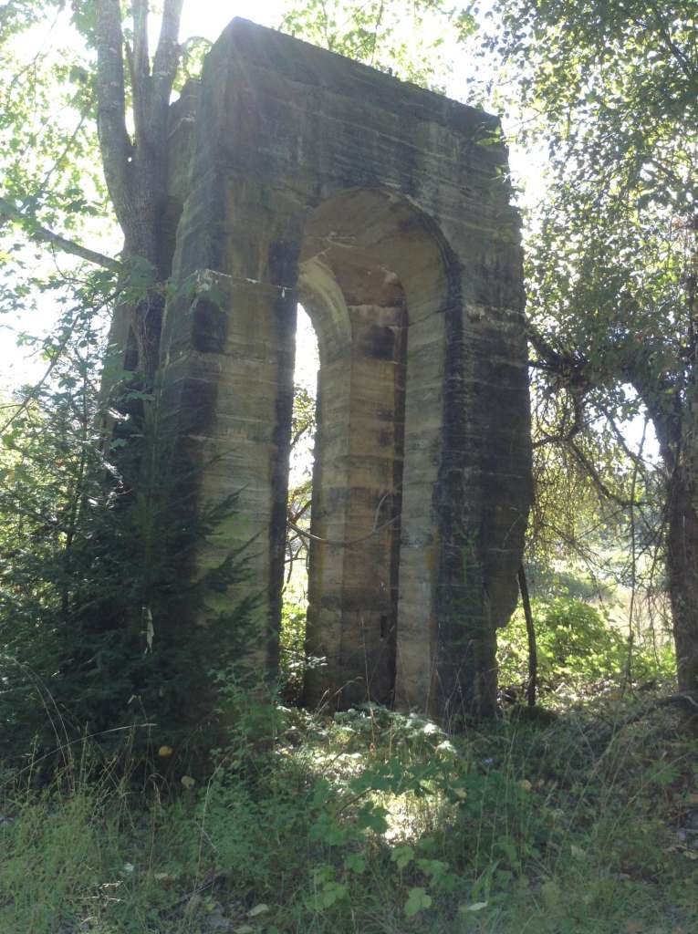
Concrete arch at the former South Wellington Mine site
photo courtesy of Maechlin Johnson
I’ve always been interested in the South Wellington Mine story because Robert Miller, an earlier owner of the property where my parents live and the builder of their barn, drowned in the 1915 accident. The Miller barn stood as a significant figure in the valley landscape in South Wellington for over 100 years, but in 2019, the old girl came down.

Barn built by Robert Miller on my parents’ property in South Wellington.
The section on the right was likely a later addition to the original loose hay barn.
While cleaning up the barn in preparation for the demolition, my dad found a miner’s tag hanging on a nail in the barn. Even though my family had lived on the property for over 30 years, we hadn’t discovered the tag. It was only when the barn’s time was coming to an end that the round, toonie-sized marker was discovered in plain sight. Miners used the tags for a variety of reasons, including indicating one’s presence underground, checking out lamps and tools, and marking cars filled with coal. They are quite collectable and my dad had been looking for one for years. While we don’t know for sure, we like to think that it was Robert Miller who hung the tag in the barn and that it may in fact be a memento from the South Wellington Mine.

Miner’s tag found in my parent’s barn
*Thank you very much to Helen Tilley for sharing her extensive research confirming that Alexandra (not Alexandria or Alexander) is the original name for the Dunsmuir mine which opened south of Nanaimo in 1884. The community that grew up around the mine (known today as South Wellington) also shared this name for a time, and I have updated this post so I don’t further contribute to the name being misremembered as Alexandria or Alexander.
Notes
- Tilley, Helen, “The Fiddick and Richardson Slopes of the South Wellington Mine,” in South Wellington: Stories From the Past (South Wellington, BC: South Wellington Historical Committee, 2016), 6.
- Wrigley’s British Columbia Directory: 1918 (Vancouver: Wrigley Directories, 1918), 424, https://bccd.vpl.ca/index.php/browse/title/1918/Wrigley%27s_British_Columbia_Directory.
 The weekend was sunny and bright, and we decided to check out the
  The impressive concrete head frame and tipple at Morden is a precious tangible remnant of Vancouver Island’s coal mining past. The structure is one of only two of its type in North America (the other one is at the
  An interpretation of the iconic looming head frame was captured by local artist Patrick Belanger for Nanaimo’s Canada 150 celebration banners which were hung at major intersections around the city. The head frame and its adjacent tipple have also been replicated at the other end of the Modern Colliery Regional Trail at Cedar Road, with smaller wooden versions standing in tribute at the trail head.
 The part of the trail at Morden follows the old PCCM rail grade, and is an easy walk through the natural forest. I was somewhat surprised to come across a small piece of rail next to the path. It’s easy to walk right by without noticing, so keep your eyes peeled. My sons loved the two wooden bridges, and easy access to a small pond which was home to tadpoles in various stages of metamorphosis. The trail ends at a great view of the Nanaimo River, and we instantly wished we had brought along some drinks to enjoy at the cleverly placed bench overlooking the view.
 points on the path. In the trees not far away, the PCCM arch with a crumbling 1913 date is all that remains of what was a 60 foot smokestack of the boiler plant which powered the mining operation. I know a couple who had some of their wedding photos done there, and I have to say, I’m a little disappointed that I didn’t think of it for myself – especially because I grew up in South Wellington.