A coworker who hasn’t lived on the Island very long recently asked me if I knew where South Wellington was. My eyes lit up: “Do I? Yes!” Having grown up in the tiny community just south of Nanaimo city limits, I’m always eager to talk about my home town. Those familiar with Nanaimo will also know East Wellington, or at least East Wellington Road. And yes, for a time, there were also coal mining sites called West Wellington and North Wellington in the Nanaimo area. And don’t forget about just plain Wellington, the springboard for all these naming variations. So what’s with all these Wellingtons around Nanaimo anyway?
Wellington was the starting point of it all. Before 1869, the area around Diver, Brannen, and Long Lakes had just a few farms and cabins and was known as the Wellington District. The Comox Trail, a rough path leading from Nanaimo to Comox 120 kilometres away, ran through the area. Now, I haven’t found anything to confirm this, but I suspect that the Wellington District was named some time shortly after 1852. That would be the year that Arthur Wellesley, 1st Duke of Wellington died. Wellesley was an important 19th century British military and political figure. He defeated Napoleon at the Battle of Waterloo in 1815, and served twice as Prime Minister. As one of England’s most celebrated heroes, he was mourned greatly, and was honoured in many ways including a state funeral, a poem by Alfred Tennyson, and a bronze memorial in St. Paul’s Cathedral in London. It wouldn’t be surprising if a new district in the fledgling Colony of Vancouver Island was also named in tribute.1
The timeline fits for the district getting a name after Wellesley’s death. Snuneymuxw Chief Che-which-i-kan2, known afterwards as “Coal Tyee”, had brought a canoe full of black rock to Victoria in 1850 for the HBC’s perusal. This led to Joseph McKay being sent to Nanaimo to secure the area on behalf of the company, and coal mining around the harbour got going in earnest shortly after. It would make sense that in the ensuing years, as Nanaimo developed as a townsite, people would spread out into the surrounding areas, resulting in those districts being surveyed and assigned their own names. Maps from 1859 show that the nearby Cranberry, Cedar, and Mountain Districts had also been named by this time.
In 1869, independent miner Robert Dunsmuir discovered coal near Diver Lake, just outside of the northern boundary of the Vancouver Coal Mining and Land Company’s property. (The HBC had sold its Nanaimo interests to the VCMLC in 1862). Further investigations in the area led Dunsmuir to uncover a thick new coal deposit which he called the Wellington seam. This coal discovery led to the development of Dunsmuir’s successful Wellington Colliery, with a townsite – Wellington – growing up nearby.
The original “old” Wellington townsite was north of Diver Lake and was made up of company houses for the coal miners and their families. Robert Dunsmuir died in 1889, but the Wellington Colliery remained in operation under the direction of his son James. With the success of the mines, more people came to the area, and starting in about 1890, James Dunsmuir allowed lots to be sold off to miners in a “new” Wellington townsite not far away. This would be the area on the south shore of Long Lake, with numbered streets (now 101 – 107), and distinctively British avenues.3

With the huge success of Wellington coal, the town grew fast, eventually reaching a population of over 5,000, which was larger than Nanaimo’s population at the time. But by the late 1890s, the mines were no longer the high-producing operations they had once been. The Wellington Mines closed one by one, especially once a new coal discovery at Extension drew the company’s attention southward. A fire in 1899 destroyed many of the town’s key buildings, and others were moved to the new mining communities of Extension and Ladysmith. The population dropped significantly as miners and their families moved away to pursue jobs in other mines, but Wellington continued on as a rural community until it was eventually amalgamated with Nanaimo. On January 1, 1975, Nanaimo’s boundaries expanded and Wellington, along with Harewood, Chase River, Northfield, Departure Bay, and Protection Island, became part of the City of Nanaimo.4
Few remnants of Wellington can still be see today. Some of the homes located in Extension and Ladysmith originally came from Wellington; they were transported by rail to their new locations when the miners moved away from the fading Wellington Colliery to work at the new Extension mines. Other larger buildings were also moved to Ladysmith from Wellington: the Anglican Church on Buller Street; the Temperance Hotel at the corner of First Avenue and High Street; and the Jones/Miner’s Hotel on Gatacre Street are a few that are still standing today and appear on the Town of Ladysmith’s Community Heritage Register.
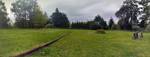
In Wellington itself, the most tangible reminder is the Wellington cemetery, quietly tucked away at the corner of Ledgerwood and Cardena Roads. This is the resting place of some of the original Wellington residents, most likely many of whom were miners or their family members. While over 100 burials are recorded, only approximately 25 markers still remain. Many are difficult to read, overgrown, or damaged. The Italian, Belgian, and Finnish names which appear on the remaining headstones reflect the diverse ethnic makeup of the mining families of Wellington. Formally recognized on the Canadian Register of Historic Places, the cemetery is quiet and peaceful. For more information about the Wellington Cemetery, make sure to check out the Nanaimo Historical Society’s virtual tour at: https://youtu.be/rYy5xcvQDhE.
While the current Island ConnectEd building (formerly Mount Benson Elementary School) only dates back to 1950, the property has a long history as the home of the school in Wellington. On May 20, 1875, on land donated by Dunsmuir for the purpose, the Wellington Public School officially opened. This first building burnt down in 1904, but another school was rebuilt on the same site. The second school was also destroyed by fire in 1944, and yet another school was built nearby. This third school was given the new name of Mount Benson Elementary, and was open until 2008. This school was closed after the 2007/2008 school year by the Nanaimo-Ladysmith School District as part of a business plan that would see the land sold to provide capital funding for other district projects.5
There was some interest raised in the Wellington area about using the closed school building for community-focused activities. Community members also brought forward a concern that the “top field” (the land originally donated by Dunsmuir) could not be sold by the school district because it was held in trust for the people of Wellington.6 The site was not sold and the former Mount Benson Elementary School building is now home to Island ConnectEd, Nanaimo Ladysmith Public Schools’ facility to support distance learning. With over 140 years of public education on its grounds, the site off of Jingle Pot Road has the distinction of being the oldest known operating public school on its original site in British Columbia.7
The Wellington Inn has also had a significant presence in the area, albeit from several different locations. The original saloon, operated by Charles “Donnybrook” Chantrell, was almost as old as the mines and was near the original townsite on the north shore of Diver Lake. Seeing an opportunity with the development of the mines, Chantrell built a larger hotel in 1875, and despite being called The Wellington Inn, most people called it Chantrell’s. The establishment burned down and was rebuilt at least once while it was near the lake. The hotel was eventually rebuilt in the new Wellington townsite, where the present Wellington Pub and Liquor store still operates on Victoria Avenue.
Even though Wellington townsite faded away once the mines closed, the Wellington name continued to spread to other parts of the Nanaimo region. To learn more about North, South, East, and West Wellington, please read my post, The Wellingtons of Nanaimo Part 2: South, East, West, North, & South Again.
Notes
1. In 1852, Vancouver Island was still its own colony. It was created in 1849, and was a separate entity until 1866, when it was joined with the mainland Colony of British Columbia.
2. Also seen as Ki-et-sa-kun.
3. Apsley Avenue was likely named either for Henry Bathurst, 2nd Earl of Bathurst, who was the Lord Chancellor of Great Britain from 1771-1778, and was known as Lord Apsley, or for his home, Apsley House, which was eventually sold to Arthur Wellesley, 1st Duke of Wellington; Wellesley Avenue was another tribute to Arthur Wellesley; Victoria Avenue named for Queen Victoria who was the reigning monarch at the time of Wellington’s development; and Corunna Avenue was likely named for the Battle of Corunna, which was considered a memorable British tactical victory against the French in the Napoleonic Wars. The naming pattern (numbered streets and British avenues) is reversed in Ladysmith, which was also named by James Dunsmuir, where the avenues are numbered and the streets carry names of British Boer War officers. For more info on Ladysmith’s street names see: https://www.ladysmithhistoricalsociety.ca/histories/street-names/.
4. Jan Peterson, A Place in Time: Nanaimo Chronicles (Nanaimo: Nanaimo Museum, 2008), 278.
5. Justine Hunter, “Sad last day as Nanaimo school shuts its doors,” Globe and Mail, June 28, 2008, https://www.theglobeandmail.com/news/national/sad-last-day-as-nanaimo-school-shuts-its-doors/article20385043/.
6. Andréa Coutu, Twitter direct message to author, July 12, 2021; “Mt. Benson School History,” YouTube video, 7:30, “wellingtonbcaca,” March 3, 2011, https://www.youtube.com/watch?v=ll6pW29hu1k.
7. For more information about the history of the school site see: http://www.mountbensonschool.ca/. Note: There is also a high school in Nanaimo called Wellington Secondary. This is at a separate site at 3135 Mexicana Road. The high school opened in 1967, initially as a junior high, but now has grades 8 through 12.

Hello,
I am currently undertaking some environmnental work on the south shore of Brannen Lake (within the correctional centre). I am aware of the North Wellington mine to the south east of the site. I just wondered if you knew of any mining having taken place within the site? or had any old maps of the area.
LikeLike
Hi Andrew, I would suggest that you contact either the Nanaimo Community Archives or the City of Nanaimo to see if they could provide you with more information and/or historic mining maps.
Also, there is a book you might find useful called Coal Mine Underground Workings Atlas: Nanaimo Area, Lantzville, South Wellington, Cassidy & Extension which was produced in 2004 by Shari Lindsay of Pacific Spatial Systems Ltd. (an environmental mapping and GIS consulting business). The archives probably has a copy, but if not, several of the local Vancouver Island Regional Library branches have a copy in their reference collections.
Best of luck!
LikeLike
Read an article today in News Bulletin about brick manufacturing on Gabriola & in Nanaimo during coal years. Wanted to find specific details of the source of much of that brick clay. I believe that #6 Shaft Wellington Colliery produced significant amounts. On a second matter, two more streets were identified on the original blueprint of Wellington (South of Long Lake) being Napoleon and Waterloo. This tends to confirm the other names are related to the Duke of Wellington. Did Dunsmuir’s Victoria Castle resemble Apsley House?
LikeLike
Yes, I’ve read in the Wellington, B.C. Wikipedia article that Waterloo and Napoleon were additional Wellington street names that never came to be. I’d love to know where that information came from, as I’ve never read that anywhere else, but unfortunately, there’s no citation on the Wikipedia page. I don’t doubt it though, the same thing happened in Ladysmith, where Dunsmuir named the streets after British military personnel in the Boer War. There were a couple of names chosen that were never used: Wauchope, Otter, Colville, and MacDonald. They appear on this 1901 map used to promote the town: https://www.ladysmithhistoricalsociety.ca/wp-content/uploads/2015/07/Ladysmith-map-old.pdf
LikeLike
Sorry that I didn’t see your reply. The secretary of Wellington, Kay Zboyovski, had an original blueprint of the community layout from the lands purchased from Dunsmuir. It was given to the City after amalgamation. Hence the last two street names. Country Club Centre and the old Starlight Drive-in would on those Avenues.
LikeLiked by 1 person